A Pilgrimage into the Canyon: Attempting the Hopi Salt Trek
Setting Out on a Long-Awaited Journey
June 2025: At the end of June, over a three-day weekend, I headed to northern Arizona with my nephew, Hayden, to attempt the Hopi Salt Trek — a hike I had been wanting to do for years.
This route is accessible only by a 4WD track through Navajo tribal lands and is known for its remoteness and rugged terrain. The trail itself is poorly maintained, requiring plenty of rock scrambling and careful footing.
A Sacred Path of the Hopi People
The Hopi Salt Trail is steeped in cultural and spiritual significance. For generations, it has been a pilgrimage site for adolescent Hopi males, marking a rite of passage into manhood.
The journey leads down to the Little Colorado River at the bottom of the canyon, where participants collect salt to carry back to the top.
-
The river and its springs are believed to be the origin of life for the Hopi people.
-
Along the way, hikers encounter sacred rock paintings that tell stories of ancestry and tradition.
-
The turquoise hue of the river comes from salt deposits seeping into the water, giving the canyon an otherworldly glow.
Why the Trek Calls to Adventurers
Even beyond its cultural depth, this hike has a strong allure:
-
Challenging terrain
-
Seldom visited and isolated from the crowds
-
Majestic landscapes that feel untouched by time
An Unfinished Quest
We didn’t end up completing the hike this time and decided to reschedule for another attempt. Still, I got a valuable preview of the trail and the surrounding area — enough to fuel my determination to return.
Exploring Northern Arizona’s Hidden Gems
Although the trek itself remained unfinished, the trip was far from a loss. Over the weekend, we managed to explore an incredible variety of sites, including:
-
A vast lava cave formed by ancient volcanic flows
-
The impressive Meteor Crater, a reminder of Earth’s cosmic collisions
-
Pueblo ruins that whisper of centuries past
-
A dormant volcano rising over the desert landscape
-
An overnight stay in a haunted historic hotel, once a hospital in a mining boom-and-bust town turned ghost town
Looking Ahead
The Hopi Salt Trek still waits for me, and now that I’ve seen its beginning, I’m more eager than ever to return.
Next time, I’ll be ready for the challenge — to reach the turquoise waters, stand at the sacred springs, and walk in the footsteps of countless generations before me.

Hogan

My nephew on the Hopi Salt Trail

Hopi Salt Trail

Grand Canyon National Park

Barringer Crater meteorite crater

Wupatki National Monument Pueblo Ruins
Exploring Lava River Cave: Arizona’s Longest Lava Tube
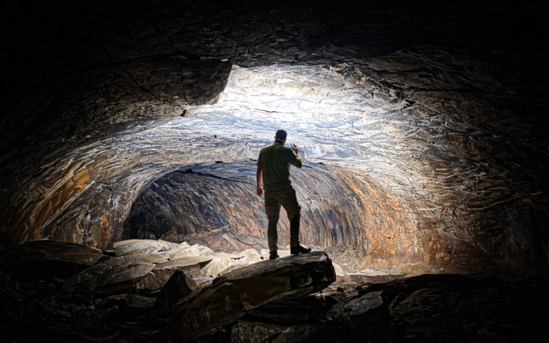
Easily a favorite for both my nephew and me was Lava River Cave, located in Coconino National Forest about 14 miles northwest of Flagstaff. This mile‑long lava tube, formed roughly 700,000 years ago during a volcanic eruption, is the longest of its kind in Arizona.
It’s completely wild — no lights, no handrails, no paved paths — just a raw, ancient tunnel of basalt where you’re free to wander on your own. We ventured about 40 minutes into the cave before turning back, making sure to get out before nightfall so we could make it to our ghost‑town accommodations. Even in that short journey, the cool air, total darkness, and echoing stillness made it unforgettable.

Lava River Cave, located in Coconino National Forest

Lava River Cave, located in Coconino National Forest
Jerome – From Copper Kings to Bohemian Revival
A Wild West boomtown reborn on the edge of the mountains
Boomtown on Cleopatra Hill
Perched dramatically on the slopes of Cleopatra Hill, Jerome sprang to life in the late 1800s when rich copper deposits were discovered. By the 1920s, it had swelled to nearly 15,000 residents—mostly miners, gamblers, and fortune-seekers. In those days, Jerome was infamous for its saloons, gambling halls, and brothels, earning it a reputation as one of the rowdiest towns in the West.
From Underground Tunnels to Ghost Town
Mining began with deep underground tunnels but later expanded into massive open-pit operations under Phelps Dodge. By the 1930s, the copper veins were thinning, and when the last mine closed in 1953, Jerome’s population plummeted to fewer than 100, leaving behind a crumbling shell of a once-thriving community.
Artists Bring the Town Back to Life
In the 1960s and ’70s, painters, sculptors, musicians, and free spirits began moving in, restoring weathered buildings and transforming Jerome into the quirky, bohemian hillside town it is today—part ghost town, part creative haven, and still clinging stubbornly to its Wild West spirit.
A Night in the Haunted Hospital
That night, we stayed in the Jerome Grand Hotel, formerly the United Verde Hospital. Built in 1926 in the Spanish Mission style, it was the most modern hospital in Arizona at the time, complete with an Otis elevator that still runs today. Perched high on Cleopatra Hill, it served the booming mining town for decades, treating sick, injured, and dying miners. Over the years, more than 9,000 people passed away here—many from mining accidents or illnesses caused by the dangerous conditions underground.
After the mines closed, the hospital sat abandoned for decades. Locals whispered of strange happenings: footsteps echoing in empty corridors, the faint scent of flowers where no plants were present, and the ghostly figure of a nurse drifting through the halls. When it was renovated into a hotel in the 1990s, it kept its eerie reputation intact.
One of the most haunted rooms—Room 32—was just a few doors down from ours, known for flickering lights and sightings of a tall, shadowy figure. Sadly (or perhaps fortunately), no spirits made themselves known to us that night, though the weight of the building’s history lingered in every creak of the floorboards.

Jerome

Jerome Grand Hotel